
Geography
Topographic map of the Cembrian Isles
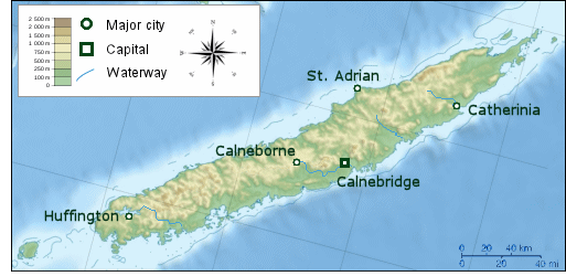
Cembria was formed as an island through tectonic activity. It is known as the most mountainous island in the Landaran Sea. The total area of the Grand Kingdom of Cembria is approximately 20,273 square kilometres (7,827 sq mi). It consists of the island of Cembria, the southwestern island of St. James, and smaller surrounding islands such as Sherwick Isle (NE) and the Postl Archipelago (SW). The Cembrian Isles lie within the Landaran Sea (officially the Thecious Ocean westward), coming within 70 kilometres (44 mi) of the coast of western Canalk, from which it is separated by the Landaran Sea.
It lies between latutudes 45° and 47° N, and longitudes 13° and 17° E. The 15th meridian east almost corresponds to the middle line of the country in the direction west-east. The geographical centre of Cembria is at the coordinates 46°07'11.8" N and 14°48'55.2" E. Cembria's highest peak is Mt. Bright (1,628 m/5,341 ft); the country's average height above sea level is 557 m (1,827 ft).
It lies between latutudes 45° and 47° N, and longitudes 13° and 17° E. The 15th meridian east almost corresponds to the middle line of the country in the direction west-east. The geographical centre of Cembria is at the coordinates 46°07'11.8" N and 14°48'55.2" E. Cembria's highest peak is Mt. Bright (1,628 m/5,341 ft); the country's average height above sea level is 557 m (1,827 ft).
Composition & Topography
The majority of Cembrian terrain is hilly or mountainous, with around 82% of the surface 200 m (656 ft) or more above sea level. The Mainland is by far the largest of the islands, and the only mountainous island. A mountain range runs the length of the island, with five peaks over 1,500 metres (4,900 ft). The highest point is Mount Bright at 1,628 metres (5,341 ft) elevation.
Over half of the country (1,186,104 km2/457,957 sq mi) is covered by forests. This makes Cembria the third most forested country in Caprecia. The areas are covered mostly by linden, beech, fir-beech and beech-oak forests and have a relatively high production capacity. Remnants of primeval forests are still to be found, the largest in the Ashton area. Grassland covers 5,593 km2 (2,159 sq mi) and fields and gardens (954 km2/368 sq mi). There are 579 km2 (223 sq mi) of orchards.
Over half of the country (1,186,104 km2/457,957 sq mi) is covered by forests. This makes Cembria the third most forested country in Caprecia. The areas are covered mostly by linden, beech, fir-beech and beech-oak forests and have a relatively high production capacity. Remnants of primeval forests are still to be found, the largest in the Ashton area. Grassland covers 5,593 km2 (2,159 sq mi) and fields and gardens (954 km2/368 sq mi). There are 579 km2 (223 sq mi) of orchards.
Summary
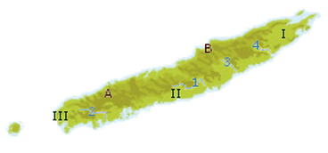
Geographical regions:
- A: Western Highlands
- B: Mid-Eastern Midlands
- 1: Calne River (Calne Valley)
- 2: Cam River (Camlake)
- 3: Rhine
- 4: Arth (Arth River Valley)
- I: Sherwick Peninsula
- II: Centre
- III: Westlands
